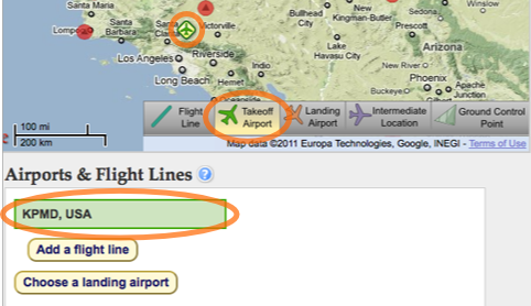
A takeoff airport must be selected in order to complete a flight plan. The NASA G3 is based out of the Palmdale airport, in California.
When choosing an airport other than the Palmdale airport that NASA/Dryden operates, keep in mind that NASA/Dryden is responsible for aircraft operations. The G3 mission operations may require specific facilities for landings and takeoff, and should be consulted.
Choose Airport
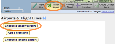
To choose an airport, click "Takeoff Airport" in the map toolbar or click the "Choose a takeoff airport" button below the map.
Use the search box and the drop-down menu which appear to the right of the map to search for airports under different criteria. After searching, select specific results which appear below the search box or click the airport icons that appear in the map until you find the desired airport.
Click the "Select Airport" button to add the takeoff airport to the flight plan. The icon for the takeoff airport you selected will stay on the map.
A video demonstration may be viewed here (no sound). We recommend using full screen and watching in HD.
Change Airport
To change the takeoff airport, follow the same steps that you took to select the airport.
There are several ways to select an existing airport: click the takeoff airport icon in the map, click "Takeoff Airport" in the map toolbar, or click the airport by name under "Airports & Flight Lines" below the map.
ww
Once the takeoff airport is selected, use the search box which appears to the right of the map to search for the desired airport. When finished, click the "Change Airport" button.
 Jet Propulsion Laboratory
California Institute of Technology
UAVSAR Home
Jet Propulsion Laboratory
California Institute of Technology
UAVSAR Home
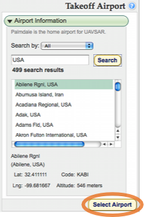 Use the search box and the drop-down menu which appear to the right of the map to search for airports under different criteria. After searching, select specific results which appear below the search box or click the airport icons that appear in the map until you find the desired airport.