
Simulated NISAR Products
Simulated NISAR products are generated from UAVSAR data to emulate NISAR data characteristics in order to help users test their algorithms and get a sense of the quality of future NISAR products. Click on the links below to go to the desired section.
Download Data
Here are the instructions to find and download simulated NISAR data.
- Use this direct link to find all simulated NISAR products or follow the steps below:
- Go to the UAVSAR page uavsar.jpl.nasa.gov.
- Click on the blue Search for Data button near the center of the page.
- Select Simulated NISAR under Specialized Products towards the top right section of the page.
- Click on the Search button.
- A list of available flight lines will be displayed on the right side of the map.
- Click on the little black arrow left of the orange flight line name to view detailed product listings. Simulated NISAR products are indicated by the hashtag #simulated-nisar under each product listing.
- Click on the view link right of the product listing to goto the product page for the desired product.
- On the product page, select the desired NISAR mode under Select product, which can be found below the Google Map. Simulated NISAR products are indicated by the hashtag #simulated-nisar above the Google Map.
- To download desired files, use the links in the Downloads section or the wget commands under wget commands to download data.
Processing Notes
Two main changes have been applied to UAVSAR SLCs to generate simulated NISAR products:
- Reduced spatial resolution: NISAR has a bigger antenna so its products have coarser azimuth resolution. Most NISAR modes transmit less RF bandwidth, so its products will also have coarser range resolution.
- Added noise since NISAR has lower signal-to-noise ratio (SNR) due to operating at much longer range despite having a bigger antenna.
Please note that simulated NISAR products have center frequencies that are closer together than actual NISAR bands will be. They were selected to fall in the UAVSAR spectrum sweet spot. Simulated NISRA products also always contain all four polarizations so users can extract a variety of NISAR modes from the data.
| Simulated NISAR Mode | Center Frequency | Bandwidth |
|---|---|---|
| 20+05 MHz Frequency A | 1243.0 MHz | 20.0 MHz |
| 20+05 MHz Frequency B | 1270.0 MHz | 5.0 MHz |
| 40+05 MHz Frequency A | 1253.0 MHz | 40.0 MHz |
| 40+05 MHz Frequency B | 1275.5 MHz | 5.0 MHz |
The simulated NISAR product version keeps track of the various updates the product contains. The simulated NISAR product version can be found in the NISAR RSLC HDF5 (.h5) file field "science/LSAR/identification/productVersion", or for versions 0.3 to 1.1, the annotation (.ann) file field "Simulated NISAR Product Version Number." Note this is different from the two-digit UAVSAR product version near the end of the file name, which tracks both UAVSAR and simulated NISAR products.
Version 2.0
- Conform to updated NISAR RSLC Product Specification Version 1.2.1.
- Added GCOV products
- Simplified released products by removing UAVSAR format files (*.slc, *.mlc, *.grd, *.slope, *.inc, *.rtc, *.hgt, *.kmz, ).
- Processed with Copernicus DEM, the same DEM that NISAR plans to use for processing.
Version 1.1
- Added PRF dithered GRD files derived from dithered RSLC HDF5 files. The dithered GRD files are all co-registered with non-dithered GRD files. For more details on the dithering simulation, please see this document.
- Added annotation files for dithered products, including information on the dithering simulation such as gap size, gap fraction, and average PRF.
- Added #dithered tag to products that contain dithered RSLC HDF5, GRD, and annotatation files.
- Fixed bug in product URL in simulated NISAR annotation files.
Version 1.0
- Added PRF dithered RSLC HDF5 files to simulated NISAR products. This is a radar mode where the pulses are staggered in order to shift the TX gaps around, which allows the processor to interpolate across them. For more details on dithering simulation, please see this document.
- Added #dithered-hdf5 tag to products that contain dithered RSLC HDF5 files.
- Fixed Doppler from patch to patch to eliminate phase discontinuities in the near range.
- Fixed bug in annotation field "Fraction of Swath with NISAR Doppler Overlap" that always reported 1.
- Updates to NISR RSLC HDF5 files
- Fixed "processedAzimuthBandwidth" which was too small by a factor of 2.
- Changed "productType" from "SLC" to "RSLC"
- Added "cycleNumber" although the value is set to invalid number of 0 since it's not applicable to UAVSAR instrument.
Version 0.4
- Updated calibration for data acquired on flights 19033-19049 so power is more uniform among different modes.
Version 0.3
- Made all GRD data for a product lie on the same grid.
- Added "Simulated NISAR Product Version" to annotation file, mirroring NISAR RSLC HDF5 file "LSAR/identification/productVersion" field.
Version 0.2 (or no field "Simulated NISAR Product Version Number" present in annotation file)
- Improved range resolution
- Adjusted center frequencies of simulated NISAR bands
- Added azimuth command band filtering
- Improvements in SNR accounting
- Updated mode table to adhere to latest NISAR definition
- Added UAVSAR gain calibration term
- Incorporated effects of range and azimuth filtering
- Accounted for polarization dependence
- Harmonized calibration across range subbands
- Added radiometric terrain correction (RTC) layer
- Added mode-dependent multilooking
- Used crosstalk-corrected SLCs (using non-crosstalk corrected SLCs is also an option)
- Updated geocoded product posting
- Added geolocation metadata and state vector postings in NISAR RSLC HDF5 file
Version 0.1 (or no field "Simulated NISAR Product Version Number" present in annotation file)
- First batch of simulated NISAR products that have all been discontinued.
Product Description
Simulated NISAR products are specialized UAVSAR PolSAR products in NISAR format (HDF5 files). NISAR product descriptions and specifications can be accessed here.
NISAR RSLC HDF5SLC files packaged in NISAR Level 1 Range Doppler Single Look Complex (RSLC) HDF5 format. Each NISAR RSLC HDF5 file contains SLCs for both frequencies of a particular mode (i.e. 129A and 129B). The file extension is h5.
NISAR GCOV HDF5NISAR Level 2 SAR covariance product in geocoded coordinates, generated from RSLC product using ISCE3
For older version (<2.0), they include files described in the UAVSAR PolSAR Data Format but with different number of MLC looks and GRD grid, radiometric terrain correction layer, and flat earth incidence angle files described below.
Simulated NISAR MLC looksThe following MLC looks are selected to generate MLC spacing that equates as close to 10 meter GRD spacing as possible based on given SLC spacing and integer number of looks. 10 meter GRD spacing was selected so users would have room to form different larger spacing.
| Mode | 129A | 129B | 138A | 138B | 143A | 143B | UAVSAR |
| Bandwidth | 20 MHz | 5 MHz | 40 MHz | 5 MHz | 20 MHz | 20 MHz | 80 MHz |
| MLC Range Looks | 1 | 1 | 2 | 1 | 1 | 1 | 4 |
| MLC Azimuth Looks | 2 | 2 | 2 | 2 | 2 | 2 | 22 |
| MLC Azimuth Spacing (meters) | 13.2 | 13.2 | 13.2 | 13.2 | 13.2 | 13.2 | 13.2 |
| MLC Slant Range Spacing (meters) | 6.246 | 24.983 | 6.246 | 24.983 | 6.246 | 6.246 | 6.246 |
| Associated Ground Range Spacing (meters) | 9.72 | 38.87 | 9.72 | 38.87 | 9.72 | 9.72 | 9.72 |
Simulated NISAR GRD Grid
All the ground projected products have latitude spacing of 0.0001 degree. Different products have different longitude spacing depending which latitude zone the peg latitude fall in (defined in the annotation file). The GRD starting location also snap in 0.0001 degree latitude and 0.0012 degree longitude increments.
| Latitude Zone | +/- 0 to 50 deg | +/- 50 to 70 deg | +/- 70 to 75 deg | +/- 75 to 80 deg | +/- 80 to 90 deg |
| Longitude Spacing | 0.0001 deg | 0.0002 deg | 0.0003 deg | 0.0004 deg | 0.0006 deg |
Three additional types of files are also generated for the NISAR community:
RTCEach GRD file can be multiplied by the radiometric terrain correction file to correct for the impact of terrain topography on the radar backscatter. The correction is computed using the Hybrid Projection Angle method described in this paper. The corrected value is gamma0.
| Extension | Type | Format | Bytes Per Pixel | Units | Projection |
| rtc | binary | real*4 floating point | 4 | - | ground range equiangular |
Flat Earth Incidence Angle File
Incidence angle layer based on flat earth DEM.
| Extension | Type | Format | Bytes Per Pixel | Units | Projection |
| flat.inc | binary | real*4 floating point | 4 | radians | ground range equiangular |
All binary file are in little endian byte order with no header bytes.
Dithered productsPlease see this document for information about dithered products.
Naming Convention
The simulated NISAR product names conform to the following naming convention:
Sitename_LineID_FlightID_DT_Date_BandSquintPol_XtalkDither_NMode_Version.Ext
This adds the field NMode to the standard UAVSAR PolSAR naming convention.
| Field Name | Characters | Field Description |
| Sitename | 6 | Abbreviated name for the target site |
| LineID | 5 | ID that describes a unique track, where the first 3 digit aircraft heading is followed by a 2 character incremental counter. |
| FlightID | 5 | Flight ID describing the unique flight the line is flown in, where the first two digits are the last two digits of the year, and the next three digits are the flight number counted sequentially from the first flight of the year. |
| DT | 3 | Data take counter indicating which acquisition during the flight this data was from, counted sequentially from the beginning of the flight and starting from zero. |
| Date | 6 | Acquisition date in YYMMDD format indicating the year, month, and day the data was collected in UTC time. |
| BandSquintPol | 4 | A single character indicating the frequency band, followed by the steering angle (three digits), sometimes followed by the polarization. If applicable, the polarization may be between 2 characters (first character is the transmit polarization, and second character is the receive polarization) and 4 characters (if the file represents a cross product) |
| Xtalk | 1 | Indicates whether cross talk has been calibrated or not: X - no crosstalk calibration, C - cross talk calibration has been applied. |
| Dither | 1 | Indicates whether the data has been dithered or not: X - not dithered, G - dithered with gaps, D - dithered with no gaps. |
| NMode | 4 | Simulated NISAR mode equivalent. For version 2.0 and above, this consists of the bandwidths of the two simulated bands (ex. 2005 = 20 MHz + 5 MHz) followed by the polarization for each band (QP=quadpol). For earlier versions, it consists of a 3-digit mode number associated a specific center frequency, bandwidth, and polarization, and followed by 1 character indicating the frequency (A or B). |
| Version | 2 | UAVSAR product version number. Increments with new product release of the same acquisition. |
| Ext | 2-5 | File extension |
Known Issues
Simulated NISAR RSLC HDF5 files contain CFloat32 values instead of CFloat16NISAR product specifications for RSLC HDF5 indicates that the complex values are CFloat16, but the simulated NISAR product RSLC HDF5 files contain CFloat32 complex values since the product specifications were not updated when the simulated products were initially being produced. The CFloat32 format was preserved to keep the simulated products consistent.
~3 dB radiometric offset between dithered and non-dithered productsDithered products (variable PRF products with G or D in the product name) has approximately 3 dB radiometric offset from the non-dithered products (fixed PRF products with X in the product name). This is due to the apodization windows used during the simulation of dithered products.
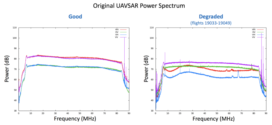
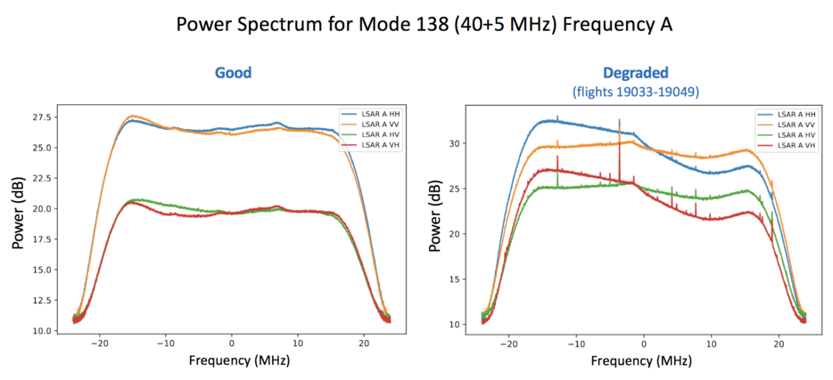
Degraded radar performance for data acquired June 6 - July 17, 2019UAVSAR hardware issues affected data acquired June 6 - July 17, 2019 (flights 19033-19049), resulting in degraded power spectrum for the original UAVSAR data. This translates to degraded power spectrum for the simulated products, which is most prominent in the 138A data. Polarization-dependent calibration corrections have been applied when processing the degraded dataset to compensate for the difference.
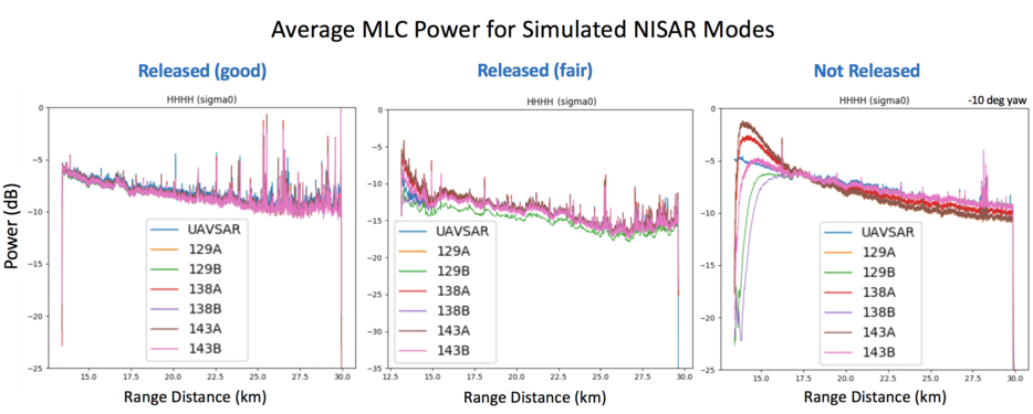
Backscatter values may vary across different modes
Backscatter values may vary up to ~3 dB within the NISAR incidence angle range. This is partly due to variations in the UAVSAR range spectrum over time. The near range variations can be much larger when the data is collected with high yaw since UAVSAR has been reskewed from global Doppler to zero Doppler. However, the large variations are typically outside of the NISAR incidence angle range. Another factor that may contribute to the variation is radio frequency interference (RFI) since RFI is range dependent and the NISAR mode are subsampled at different part of the UAVSAR range spectrum.
Product page kml file does not load
Somtimes the radar image does not load on the product page Google Map. It is an issue with Google Map responsiveness. In certain cases, reloading the page helps.