Deployment not found. Please find a deployment on the search page.
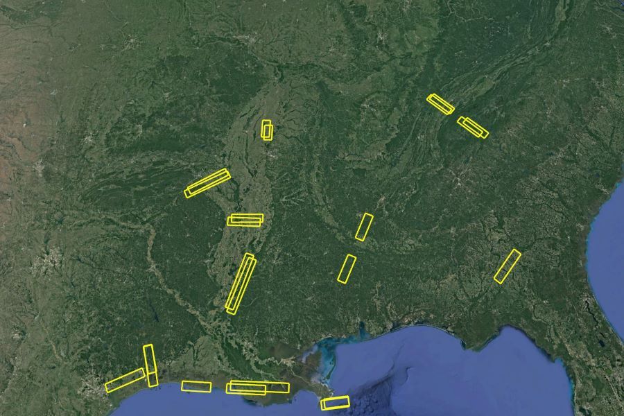
NISAR UAVSAR AM-PM Campaign Deployment (L-band)
Jun 6–Oct 30, 2019
This deployment is open to flight request submissions through the SOFRS page. If you need any assistance, please contact us.
Southeastern United States
The NISAR UAVSAR AM-PM campaign will collect radar data during a growing season in the Southeastern United States. The data will be acquired in approximately 12-day intervals over a series of alternating morning and afternoon flights. NISAR supports research for four main topics which include ecosystems, hydrology, natural hazards, and the cryosphere. This campaign aims to provide imagery and data for the ecosystem topic since this topic currently lacks proxy data. The proxy data collected during this campaign will guide the development of NISAR ecosystem science algorithms. This campaign not only advances NISAR pre-launch but also investigates the generation of science products possible after the launch of NISAR in 2022.
Adeli, S., Salehi, B., Mahidanpari, M., Quackenbush, L.J. Chapman, B. (2021). Moving Towards L-Band NASA-ISRO SAR Mission (NISAR) Dense Time Series: Multi-Polarization Object-Based Classification of Wetlands using Two Machine Learning Algorithms. Earth and Space Science. Paper / Peer-reviewed
Adeli, S., Salehi, B., Mahidanpari, M., Quackenbush, L.J. & Chapman, B. (2021). Wetland Classification Using Simulated NISAR Data: a case study in Louisiana. 2021 IEEE International Geoscience and Remote Sensing Symposium IGARSS. Paper / Peer-reviewed
Anconitano, G., Lavalle, M. & Pierdicca, N. (2021). Sensitivity to Soil Moisture Over an Agricultural Area by Exploiting a Model-Based Polarimetric Decomposition. 2021 IEEE International Geoscience and Remote Sensing Symposium IGARSS. Paper / Peer-reviewed
Anconitano, G., Lavalle, M., Arabini, E. & Pierdicca, N. (2021). Sensitivity to soil moisture by applying a model-based polarimetric decomposition to a time-series of airborne radar L-band data over an agricultural area. Microwave Remote Sensing: Data Processing and Applications. Paper / Peer-reviewed
Armston, J. D., Dubayah, R., Qi, W., Urbazaev, M., May, P., and Saarela, S., "On the synergy of the NASA GEDI and NASA/ISRO NISAR missions for monitoring ecosystem structure and biomass", AGU Fall Meeting, San Francisco, USA, 2023. Abstract
Brancato, V. & Fattahi, H. (2021). UAVSAR Observations of InSAR Polarimetric Phase Diversity: Implications for NISAR Ionospheric Phase Estimation. Earth and Space Science 8. Paper / Peer-reviewed
Chapman, B., Russo, I.M., Galdi, C., Morris, M., di Bisceglie, M., Zuffada, C. & Lavalle, M. (2021). Comparison of Sar and CYGNSS Surface Water Extent Metrics Over the Yucatan Lake Wetland Site. 2021 IEEE International Geoscience and Remote Sensing Symposium IGARSS. Paper / Peer-reviewed
Chapman, B., Siqueira, P., Saatchi, S., Simard, M. Kellndorfer, J. (2019). Initial results from the 2019 NISAR Ecosystem Cal/Val Exercise in the SE USA. Geoscience and Remote Sensing (IGARSS), IEEE International Symposium, Yokohama, Japan Paper / Peer-reviewed
Chapman, B.D., Russo, I.M., Galdi, C., Morris, M., di Bisceglie, M., Zuffada, C., Downs, B., Lavalle, M., Loria, E. & OaBrien, A.J. (2022). Comparison of SAR and CYGNSS Surface Water Extent Metrics. IEEE Journal of Selected Topics in Applied Earth Observations and Remote Sensing 15, 3235–3245. Paper / Peer-reviewed
Downs, B., Aristizabal, F., Lavalle, M., Chapman, B., Russo, M., Bisceglie, M., Galdi, C., O'Brien1, A., and Zuffada, C., "Observing Dynamic Flooding on Short Timescales by Combining GNSS-R and Height Above Nearest Drainage," AGU Fall Meeting, New Orleans, USA, 2021 Abstract
Downs, B., Chapman, B., Russo, I.M., Lavalle, M., di Bisceglie, M., Galdi, C., Morris, M., O’Brien, A. & Zuffada, C. (2021). Leveraging Nisar Activities to Support CYGNSS Wetlands Calibration & Validation. 2021 IEEE Specialist Meeting on Reflectometry using GNSS and other Signals of Opportunity (GNSS+R). Paper / Peer-reviewed
Huang, X., Reba, M., Coffin, A., Runkle, B.R.K., Huang, Y., Chapman, B., Ziniti, B., Skakun, S., Kraatz, S., Siqueira, P. & Torbick, N. (2021). Cropland mapping with L-band UAVSAR and development of NISAR products. Remote Sensing of Environment 253, 112180. Paper / Peer-reviewed
Huang, X., Runkle, B.R.K., Isbell, M., Moreno-Garca, B., McNairn, H., Reba, M.L. Torbick, N. (2021). Rice Inundation Assessment Using Polarimetric UAVSAR Data. Earth and Space Science 8. Paper / Peer-reviewed
Jensen, D., Cavanaugh, K.C., Simard, M., Christensen, A., Rovai, A. & Twilley, R. (2021). Aboveground biomass distributions and vegetation composition changes in Louisiana’s Wax Lake Delta. Estuarine, Coastal and Shelf Science 250, 107139. Paper / Peer-reviewed
Kalecinski, N. I., Skakun, S., Torbick, N., Huang, X., Franch, B., Roger, J.-C., Vermote, E. (2024). Crop yield estimation at different growing stages using a synergy of SAR and optical remote sensing data. In Science of Remote Sensing (Vol. 10, p. 100153). Elsevier BV. Paper / Peer-reviewed
Kalecinski, N., Skakun, S., Roger, J.C., and Vermote, E., "OPTICAL AND RADAR DATA SYNERGIE TO CAPTURE INTRA/INTER FIELD YIELD VARIABILITY," AGU Fall Meeting, New Orleans, USA, 2021 Abstract
Khati, U., Lavalle, M., Shiroma, G.H.X., Meyer, V. & Chapman, B. (2020). Assessment of Forest Biomass Estimation from Dry and Wet SAR Acquisitions Collected during the 2019 UAVSAR AM-PM Campaign in Southeastern United States. Remote Sensing 12, 3397. Paper / Peer-reviewed
Kraatz S., Rose S.R, Cosh M.H, and Siqueira P."NISAR UAVSAR AM-PM Campaign: An evaluation of UAVSAR L-Band Radar Over Agricultural and Forested Areas for Crop Identification and Biomass Estimation", AGU Fall Meeting, San Francisco, USA, 2019 Abstract
Kraatz, S., Rose, S., Cosh, M.H., Torbick, N., Huang, X. & Siqueira, P. (2021). Performance Evaluation of UAVSAR and Simulated NISAR Data for Crop/Noncrop Classification Over Stoneville, MS. Earth and Space Science 8. Paper / Peer-reviewed
Kraatz, S., Siqueira, P. & Rose, S. (2020). ISCE Docker Tools: Automated Radiometric Terrain Correction and Image Coregistration of Uavsar MLC Data. IGARSS 2020 - 2020 IEEE International Geoscience and Remote Sensing Symposium. Paper / Peer-reviewed
Kraatz, S., Siqueira, P., Kellndorfer, J., Torbick, N., Huang, X. & Cosh, M. (2022). Evaluating the robustness of NISAR’s cropland product to time of observation, observing mode and dithering. Earth and Space Science. Paper / Peer-reviewed
Marco Lavalle, Unmesh Khati, Gustavo Shiroma, and Bruce Chapman (2020). Assessment of PolSAR and InSAR Time-Series from the 2019 NASA AM-PM Campaign for Above-Ground Biomass Estimation. Geoscience and Remote Sensing (IGARSS), IEEE International Symposium. Abstract / Peer-reviewed
Ni, J., Tian, K., Lpez-Martnez, C., Zhan, Y., Lin, X., Tao, D. (2024). HAG-Former: A Temporal-Polarimetric Relationship Inference Network From Local to Global. In IEEE Geoscience and Remote Sensing Letters (Vol. 21, pp. 1-5). Institute of Electrical and Electronics Engineers (IEEE). Paper / Peer-reviewed
Prasad, A. R., Kumar D C, S., Hegde, A., Rananavare, L. B. (2024). Utilizing H/A/Alpha Decomposition on Simulated NISAR Data for Water Body Mapping. In 2024 IEEE International Conference on Electronics, Computing and Communication Technologies (CONECCT) (pp. 1-6). Paper / Peer-reviewed
Rosen, P., and Meyer, F., "The NISAR ASF Partnership: Thick as Thieves and Tied at the Hip for Open Science," AGU Fall Meeting, New Orleans, USA, 2021 Abstract
Siqueira, P., and Kraatz, S., "Evaluation of time-dependent features in the Ecosystems UAVSAR interferometric data from NISAR's AM/PM campaign," AGU Fall Meeting, Online, 2020 Abstract