Technology > Calibration > NISAR Calibration
NISAR Mission
The NISAR mission is a satellite SAR jointly developed by NASA and ISRO, India's space agency. The NASA-ISRO SAR (NISAR) mission will measure our planet's changing ecosystems, dynamic surfaces, and ice masses. This will provide scientists with valuable information about biomass, natural hazards, soil moisture, and sea-level rise.
NISAR Calibration
Post-launch cal/val activities may involve imaging well established ground targets. NISAR cal/val will partially use a Corner Reflector (CR) array as these targets are commonly used for SAR systems. As many as 20 corner reflectors located in NISAR's swath over the Oklahoma and Texas areas will be deployed for NISAR calibration. Additional corner reflectors will be deployed near Fairbanks and Delta Junction, Alaska.
Alaska NISAR Calibration Array
Construction
Each NISAR CR measures 2.8 meters (9.2 ft) and is a triangular-trihedral reflector constructed with 0.125" Aluminum Alloy 5052 H32 perforated sheets with staggered round holes of size 0.188". They are retained to the ground with 1/16" guy-wires pulled down to the ground with turnbuckles attached to duckbill anchors buried 18" into the ground. The front and rear wooden platforms rest on 2" high cinder blocks attached with wedge anchors and held down by 14" metal stakes.

Front Platform

Rear Platform
The University of Alaska at Fairbanks (UAF) CR measures 3.0 meters (9.8 ft) and is also a triangular-trihedral reflector. It is mounted on a ring stand and can be rotated to other azimuth directions.

Front View UAF 3.0 m CR N31A

Side View UAF 3.0 m CR N31A
Deployment
Initial deployment of two 2.8 m NISAR Corner Reflectors occurred in late August 2021 near Delta Junction, Alaska. Two additional 3.0 m UAF Corner Reflectors were also deployed, one also near Delta Junction, and the other near Fairbanks. The image below is of N01A. Signage was also placed with all the deployed CRs

N01A facing mostly West

Metrology of N01A at the Panoramic Bison Range

Signage for N01A
Coordinates
The coordinates listed here are in IGS14 Reference Frame. See a chronology of reference frames for additional information. The coordinates are expressed as WGS-84 geodetic latitude and height above the reference ellipsoid such that:
- a = 6,378,137 meters
- f = 1/298.257222
The coordinates for the sites in Delta Junction (N01A, N02A, N32A) are referenced to epoch 01-Sep-2021 and modeled with 2.219 cms/year of plate motion with an azimuth direction of 199.28° and 0.3332 cms/year vertical. Specifically the changes in East, North, and Vertical are modeled as:
- delta_east_in_meters = -0.007327 * ( gps_time_past_01-September-2021_in_secs) / 365.25 / 86400
- delta_north_in_meters = -0.020946 * ( gps_time_past_01-September-2021_in_secs) / 365.25 / 86400
- delta_vertical_in_meters = +0.003332 * ( gps_time_past_01-September-2021_in_secs) / 365.25 / 86400
These rates are from the multi-year time series analysis of the permanent PBO site AC71 as here.

Nearby velocity vectors from multi-year GPS analysis.
The coordinates for the site near Fairbanks (N31A) is referenced to epoch 01-Sep-2021 and modeled with 2.381 cms/year of plate motion with an azimuth direction of 199.14° and 0.0942 cms/year vertical. Specifically the changes in East, North, and Vertical are modeled as:
- delta_east_in_meters = -0.007809 * ( gps_time_past_01-September-2021_in_secs) / 365.25 / 86400
- delta_north_in_meters = -0.022501 * ( gps_time_past_01-September-2021_in_secs) / 365.25 / 86400
- delta_vertical_in_meters = +0.000942 * ( gps_time_past_01-September-2021_in_secs) / 365.25 / 86400
These rates are from the multi-year time series analysis of the permanent PBO site CLGO as here.

Nearby velocity vectors from multi-year GPS analysis.
Corner Reflector (CR) Data
KMZ file NISAR and UAF CRs in Alaska. In orange are the NISAR 2.8-m and UAF 3.0-m trihedral corner reflectors. In green are potential 3.0-m UAF CR locations and in pink are potential 2.5-m UAF CR locations.
Use the 'Get Corner Reflector Data' button to retrieve the vertices of the the NISAR corner reflectors (latitude, longitude, orientation, etc) for a particular date. Data goes back to September 01, 2021. Output is a comma-separated value (CSV) file.
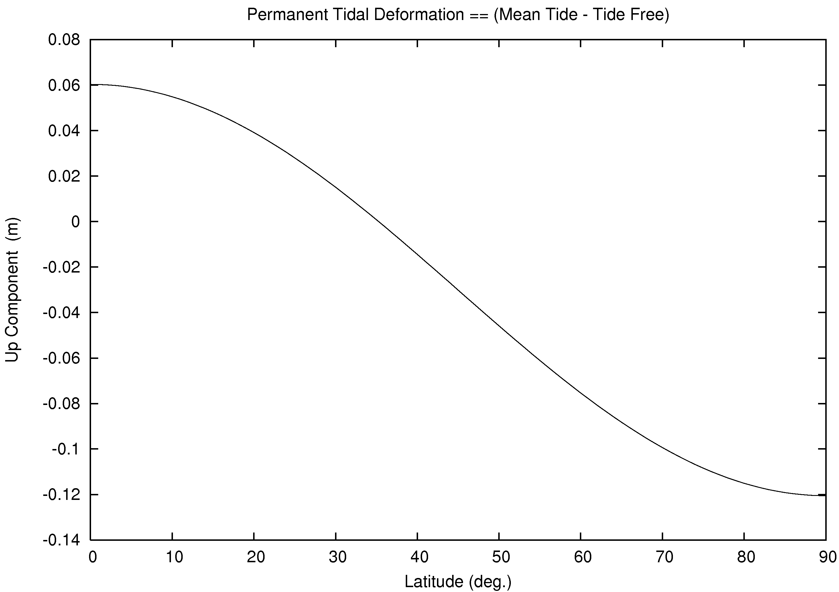
Select type tide-free for conventional tide-free crust (ITRF), select type instantaneous-crust for instantanous observed crust, and select type mean-crust for permanent tide. See for example, terrestial reference systems, particulary Figure 1.1 for additional information. The entered date applies the average plate motion of nearby GNSS sites CLGO (for N31A) or AC71 (for N32A, N02A, N01A). The date also applies the solid tide, pole tide, and ocean tide with the FES2014b Ocean Tide Model and center of mass due to both solid Earth and ocean. The reference system instantaneous-crust is a function of latitude, longitude, and the entered time. The reference system mean-crust is a function of latitude only. See for example, permanent tide deformation.
Coordinate Type:
Get Corner Reflector Data
Use the 'Get Tide Data' button to retrieve 48 hours of the tide perturbations centered at the entered date.
Get Tide Data
Contact:
Ronald Muellerschoen
Jet Propulsion Laboratory
Mail Stop 300-238
4800 Oak Grove Drive
Pasadena, California, 91109-8099
Tel: (818) 354-0717
Email: rjm@jpl.nasa.gov